>

STR Trails

As most riders may have heard, for the 2025/26 riding season, the OFSC has capped the Ontario trail network at a total of 25,500 km across the province.

This cap has led to trail reductions for all clubs under the OFSC umbrella. The purpose of this cap is to allow the OFSC to maintain trail permit prices for 2025/26 at the same level as 2024/25; to execute a more focused approach to trail management that concentrates on quality of trail vs. quantity; and better apply efficiencies across the province by ensuring trails are groomed based on conditions and demand.

Although disappointed with this news, STR understands the premise behind this approach and the anticipated savings it will realize. That being said, STR is blessed to have an extremely dedicated executive and core of volunteers, who work tirelessly managing our existing 637 km of trails.

In addition, recent years has seen STR partner with Fednor (Federal Economic Development Agency for Northern Ontario), NOHFC (Northern Ontario Heritage Fund Corporation), and enjoy continued growth in our partnership with the City of Kenora Tourism, allowing STR to make direct investments in trail grooming equipment, shelter upgrades, and communication strategies.

We feel that with our STR team and partners, we have the structure and resources in place to ensure those trails originally designated for closure, remain open under the direct management of STR. As a result, STR is pleased to announce that for the 2025/26 riding season, the entire 637 km network of STR trails will remain open for the upcoming season.

We believe strongly that our trail network, nestled in Kenora and surrounding areas of Lake of The Woods, provides one of the premier riding destinations in the country. As with all volunteer organizations however, we are only as strong as our members who sacrifice their time to manage our network, and for those who reside in Kenora, have lake homes in Kenora, or visit our region as a snowmobile destination, to buy permits and support the club.

The entire STR team looks forward to seeing you on the trails this upcoming season, and welcome those who would like to volunteer with our club to ensure our trails are the best managed in all of Ontario.

See you on the trail!!

Please ensure you Buy Where You Ride

Select Sunset Trail Riders as your club

during your online permit purchase.

MAY WE HAVE YOUR ATTENTION PLEASE

2025 Ontario Snowmobile Trail Permits are now available online at https://permits.ofsc.on.ca!!

You will be happy to note that there is no fee increase this season but purchasing now through November 1st is the best value for your money and  fees are in effect until November 1st.*

Your permit purchase supports club volunteer efforts and investments into the provincial snowmobile trail network through groomer acquisitions and refurbishment, infrastructure maintenance and replacement, trail preparation and grooming operations.

See you on the trails this year!!

*permit terms and conditions available online at ofsc.on.ca

Are your kids trained?

Driver training courses are available in areas across Ontario. 

Trail Report

No Results Found

The page you requested could not be found. Try refining your search, or use the navigation above to locate the post.

TRAIL UNAVAILABLE

The route is not available at this time, access is prohibited and anyone entering the property may be trespassing.

LIMITED AVAILABILITY

Access to the identified route is limited with marginal riding opportunities, snowmobilers enter with the understanding that they should exercise extreme care and reduce speed.

AVAILABLE

The identified route is accessible with the understanding that the trail will likely vary considerably in quality, attributes and terrain over it’s length.

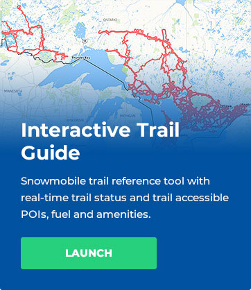
For specific trail availability details,

always consult the OFSC Interactive Trail Guide (ITG)

prior to accessing snowmobiles trails.


TRAIL DESCRIPTION TRAIL NOTE DISTANCE SHELTER
A Pipeline Trail

NO GAS available

at Stewart Lake

Kenora To Stewart Lake

Est. 57 kms / 36 miles

*See HITRAC Warm-up

shelter on L102

A Kenora Town Corridor

A/A113A Jct to A/L104 Jct

Est. 19 kms / 11.7 miles

N/A
A Kenora to Falcon Lake (MB)

Kenora to Falcon Lake (MB)

Est. 58 kms / 36 miles

Enns Brothers Warm-Up

shelter (Rush Bay)
GPS Location:
N 49.39723 W 94.56604

A113A

A/A113A Jct to

Sioux Narrows


A/A113A Jct to A113A/L108 Jct

(Via LOTW and Hydroline Trail)

Est. 65kms/41 miles 

Witch Bay Warm-up shelter
GPS Location:
N 49.59720 W 94.18380
L101 West Hawk Trail

L105/L101 Jct to Longpine Lake

(Manitoba Border)

(West Hawk Lake)

Est. 50kms / 31 miles 

YamaHut Warm-up shelter (Minkaduza Lake)
GPS Location:
N 49.44585 W 94.54581
L102 Stewart Lake Trail

NO GAS available

at Stewart Lake

A113A/L102 Jct to A/L102 Jct

Est. 54 kms/34 miles

HiTrac Warm-up shelter
(Rail Lake)

GPS Location:
N 49.81468 W 93.78148

L103 Snook Lake Trail

L104/L103 Jct to Tomahawk &

Barbie’s Warm-up shelter

Est. 51 kms/32 miles 

Tomahawk & Barbie’s

Warm-up shelter

GPS Location:
N 50.10795 W94.43923

L104 Redditt Trail

A/L104 Jct to Redditt

Est. 24 kms/14.9 miles 

N/A
L105 McKenzie Trail

A/L105 Jct to Keewatin

Est. 22 kms/14 miles

N/A
L106M North West Angle Trail

Passport Required

to enter USA

L101/L106M Jct to Youngs Bay (USA)

Est. 61 kms / 38 miles

N/A
L107 Dogtooth Trail

A113A / L107 Jct to L102/L107 Jct

Est. 33 kms/ 20 miles 

N/A
L108 Dryberry Trail

L102/L108 Jct to A113A/ L108 Jct

(Sioux Narrows)

Est. 42 kms/ 26 miles 

Dick & Dolly’s Warm-up

shelter( near Dryberry Lake)
GPS Location:
N 49.37105 W 93.59099

L109 Longbow Trail

L107/L109 Jct to A/L109 Jct

Est. 22 kms/14 miles 

N/A
L110 Sunset Channel Trail

A113A/L110 Jct to L110/L106M Jct

(Hydroline Trail to North West 

Angle Trail)

Est. 54 kms / 33 miles

L111M

French Portage Narrows

Trail

Passport required

to enter USA

L110 /L 111M Jct to Oak Island (USA)

(SunsetChannel Trail to Oak Island USA)

Est. 25 kms / 15 miles 

Latest News

STR Trails

As most riders may have heard, for the 2025/26 riding season, the OFSC has capped the Ontario trail network at a total of 25,500 km across the province. This cap has led to trail reductions for all clubs under the OFSC umbrella. The purpose of this cap is to allow the...

Advertise with us!

Promote your business while supporting our club by advertising on our site!

Sponsorship Website Ad
Bottom of every webpage.
$300/yr

Contact [email protected] for more information.